


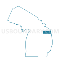
Voting Districts not defined, Alpena County, Michigan
About
Outline

Summary
| Unique Area Identifier | 595832 |
| Name | Voting Districts not defined |
| County | Alpena County |
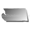
| State | Michigan |
| Area (square miles) | 1,100.45 |
| Land Area (square miles) | 0.00 |
| Water Area (square miles) | 1,100.45 |
| % of Land Area | 0.00 |
| % of Water Area | 100.00 |
| Latitude of the Internal Point | 45.02926470 |
| Longtitude of the Internal Point | -82.91534200 |
Maps


Graphs
Select a template below for downloading or customizing gragh for Voting Districts not defined, Alpena County, Michigan


Neighbors
Neighoring Voting District (by Name) Neighboring Voting District on the Map
- Voting District 0010104000001, Alcona County, MI
- Voting District 0070174000001, Alpena County, MI
- Voting District 0070174000002, Alpena County, MI
- Voting District 0070174000005, Alpena County, MI
- Voting District 0070176000001, Alpena County, MI
- Voting District 0070176000002, Alpena County, MI
- Voting District 0070176000004, Alpena County, MI
- Voting District 0070176000005, Alpena County, MI
- Voting District 0077124000001, Alpena County, MI
- Voting District 1416634000001, Presque Isle County, MI
- Voting Districts not defined, Presque Isle County, MI
- Voting Districts not defined, Alcona County, MI
Top 10 Neighboring County Subdivision (by Population) Neighboring County Subdivision on the Map
- Alpena city, Alpena County, MI (10,483)
- Alpena township, Alpena County, MI (9,060)
- Sanborn township, Alpena County, MI (2,116)
- Presque Isle township, Presque Isle County, MI (1,656)
- Alcona township, Alcona County, MI (968)
- County subdivisions not defined, Alcona County, MI (0)
- County subdivisions not defined, Presque Isle County, MI (0)
- County subdivisions not defined, Alpena County, MI (0)
Top 10 Neighboring Place (by Population) Neighboring Place on the Map
Top 10 Neighboring Unified School District (by Population) Neighboring Unified School District on the Map
- Alpena Public Schools, MI (31,006)
- Alcona Community Schools, MI (7,116)
- School District Not Defined (Water), MI (243)
Top 10 Neighboring State Legislative District Lower Chamber (by Population) Neighboring State Legislative District Lower Chamber on the Map
Top 10 Neighboring State Legislative District Upper Chamber (by Population) Neighboring State Legislative District Upper Chamber on the Map
Top 10 Neighboring 111th Congressional District (by Population) Neighboring 111th Congressional District on the Map
Top 10 Neighboring Census Tract (by Population) Neighboring Census Tract on the Map
- Census Tract 8, Alpena County, MI (3,298)
- Census Tract 3, Alpena County, MI (3,204)
- Census Tract 4, Alpena County, MI (2,989)
- Census Tract 9, Alpena County, MI (2,910)
- Census Tract 9701, Alcona County, MI (2,549)
- Census Tract 9506, Presque Isle County, MI (1,375)
- Census Tract 9900, Alpena County, MI (0)
- Census Tract 9900, Presque Isle County, MI (0)
- Census Tract 9900, Alcona County, MI (0)